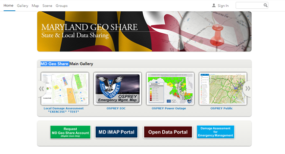
Maryland Geo Share is the second of Maryland’s ArcGIS Online Organizations. This resource is an online collection of data, maps, apps, tools, and geographic knowledge, built to maintain a strong relationship between Local, Regional, Universities and State GIS. It also offers access to groups committed to sharing data and information during emergencies and steady state to help Maryland be a more resilient, prepared, and responsive state.
MD Geo Share is a platform that not only allows local, regional and university GIS users to collaborate with the State and each other, but also allows the State to collaborate with the Federal Government Agencies.
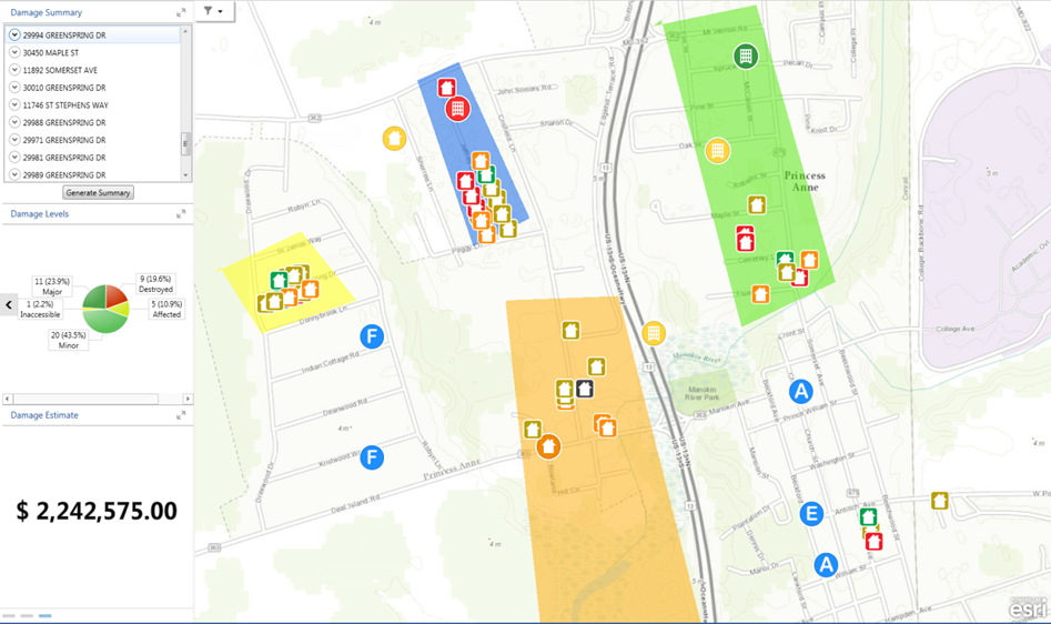
An additional benefit is the ability for Emergency Managers and GIS users within Local Jurisdictions to host and maintain a suite of damage collection tools. The Damage Collection Web Map, Collector App, and Operation Dashboard are all available to jurisdictions willing to engage them with State support.
- MD Geo Share will provide locals without an ArcGIS Online subscription to maintain and provide damage assessment tools.
- The ESRI provided Damage assessment suite of tools will reside within each jurisdiction’s Content page.
- Data can be shared using private groups between the State and Local Jurisdiction.
- Further development by the State to improve summary reports and fast track FEMA forms is being considered.
Somerset County became the first Maryland county to test out the new app called the Collector App. It is free to download and serves as a database by providing local emergency officials an electronic questionnaire, meant to be used following a natural or man-made disaster.
When they conduct door-to-door damage assessments, officials can use the app to record data which will be visible on a shared cloud storage by local, state, and federal emergency agencies. Maryland Emergency Management Agency official Will Meville says it can improve how agencies like FEMA determine the level of funding a disaster area receives.
That sort of assistance could have been beneficial during Superstorm Sandy, according to Melville. The devastating storm of 2012 triggered billions in FEMA assistance to state, local and tribal governments nationwide. Somerset county emergency planner Victoria Lloyd says this app could have helped locals stay better organized amidst the destruction.
“There was damage we didn’t know happened in areas, there was damage that was collected that we couldn’t find at the end of the day.” Says Lloyd. “With this app, all of the damage is collected in one place. We can map it out, we know where they’re hit hardest.”